Thermoplastic reliefs [1]
Map collection ETH Zurich
Starting in 1947, the Army Map Service in Washington, D.C., invented a technique using vacuum-formed plastic sheets to produce cheap reliefs in large quantities. This technique is still in use today in a moderately modernised form. It is based on the German technique of Karl Wenschow (1884–1947), which the Americans knew by the end of World War II.
First, a plaster model is made translating a contour map into a three-dimensional model using a pantograph. The Army Map Service used a block of laminated plastic sheets for the milling process, making a plaster cast from this master. This contour-stepped model then has to be finished manually by carving away the plaster steps. Today, a computer guided milling machine is able to accomplish these production steps when provided with an appropriate digital terrain model, creating a model from resin or other material.
From this master model the final reproduction mould is cast. This model consists of a material resisting heat and pressure. Fine vertical holes are then drilled in low areas. Through these holes, the air can later be evacuated when applying the vacuum.
The vacuum forming technique takes advantage of the fact that thermoplastic plastic sheets are pliant when heated to a certain temperature. After cooling down, the plastic sheets remain in the same form.
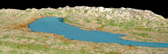
For the production of topographic reliefs, opaque white vinyl plastic sheets, printed with the map of the corresponding area are formed by means of a vacuum-forming machine. Thereby, the plastic sheet is placed over the reproduction mould, in such a way that form and sheet are joined together airtight. Then a radiant heater is placed above the plastic for about 10 seconds, heating the vinyl sheet to about 50-60 °C. Then, vacuum is applied pressing the sheet on the terrain model. After a few seconds of cooling down, the sheet can be removed. The whole procedure takes about two minutes.
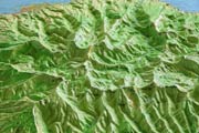
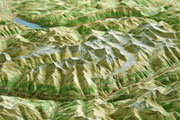
The method has its limitations due to the fact that the plastic sheet may not thin out too much. Furthermore the accuracy normally differs between different regions of the model. The points first touching the mould are depicted most accurately; the parts touching the mould last are bulged most and are less precise. For this reason, forming with a negative form is best for an accurate reproduction of valleys, while forming with a positive form enhances the reproduction quality of mountain peaks. Plastic sheets are not suitable for depicting sharp-edged or crumpled forms. They are therefore not suitable for large scale models of high mountain regions or urban regions.
To obtain a uniform thickness of the formed vinyl sheet, several techniques were developed, like blowing air through the thin holes before applying a vacuum or applying a gentle pretension of the sheet by using an additional male form. As a result, the accuracy of the points first touching the mould decreases. This limitation of heating, to avoid excessive thinning and distortion of certain regions, can be achieved by masking these regions.
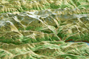
Today, not only topographic maps, but also satellite images are printed onto plastic sheets.
Map collection ETH Zurich
[1] This article bases on Spooner, Charly S. Jr. Modernization of terrain model production. 1953;
Terrain models and relief map making. 1956;
Mühle, Helmut. Herstellung von Tiefziehformen für Kartenreliefs. 1965;
Mühle, Helmut. Die Vakuumverformung von Kunststoff-Folien zu Kartenreliefs. 1967.