Relief pantograph
To quickly create relatively cheap terrain models for the public, a mechanised production technique was used in Germany, Italy, France and the USA. This historical technique uses a pantograph to guide a milling cutter. The pantograph is steered by an operator, who guides a tracing stylus along contour lines on a topographical map. The pantograph translates this motion to the milling cutter. The milling cutter, a high speed drill vertically positioned over a block of plaster, can be raised or lowered to cut at different elevations. Adjusted at the height corresponding to the contour line of the map, the drill cuts out the contours of the block of plaster. After completing the cutting at one contour level, the milling cutter is lowered to the level of the next deeper contour line, proceeding from the highest to the deepest contour line [1].
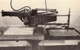
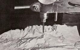
Pictures from Kneissl p.10 and Terrain models and relief map making p.34.
This method has been refined in the USA after World War II by using a zinc plate with etched contour lines to guide a gramophone needle scratching out the red colour applied to the contour lines before. The resulting step-wise model then must be prepared manually to fill the steps (as applied in Italy) or to abrade the steps (like in Germany from Wenschow) [2].
Casts were made from this master model. The casts could be sold without colouring, or a map of the same area at the same scale printed on a moulding paper could manually be applied, as made in Italy [3]. A tough, stiffened moulding paper could also be stamped between a male and a female plate of the relief, as made in France during the World War II [4]. In Germany, first a copy of the model consisting of a composite artificial wood was pressed, on which a paper map was then pressed [5]. After World War II, a vacuum forming technique was invented in the USA [6].
Karl Wenschow (1884–1947) first used this method for the large-scale production of terrain models. Starting from 1918, he produced terrain models using this method in Munich. He refined this method during World War II to create models considering the spherical curvature of the earth’s surface [7]. This, for example, allowed for estimating the coverages of radio communication antennas [8].
The pantograph was already in use in Switzerland in the 19th century to create a large relief of Switzerland by Charles Perron (1837–1909). He sold uncoloured plaster casts of the master model [9].
The basic idea of the relief pantograph has been enhanced over time. Nowadays, the technique is used to guide milling cutters by computers.
[1] Spooner, Charly S. Jr. Modernization of terrain model production. 1953. p.62.
[2] Kneissl, Max. Pillewizer, Wolf. Reliefherstellung. 1952. S.4,11,12.
[3] Kneissl, Max. Pillewizer, Wolf. Reliefherstellung. 1952. S.6-8.
[4] Reed, Harrison P.. The development of terrain model in the war. 1946. p.650.
[5] Kneissl, Max. Pillewizer, Wolf. Reliefherstellung. 1952. S.12. Gygax, Fritz. Das topographische Relief in der Schweiz. 1937. S.83.
[6] Kneissl, Max. Pillewizer, Wolf. Reliefherstellung. 1952. S.26,27. Spooner, Charly S. Jr. Modernization of terrain model production. 1953. p.61.
[7] Harrison P.. The development of terrain model in the war. 1946. p.650.
[8] Kneissl, Max. Pillewizer, Wolf. Reliefherstellung. 1952. S.1.
[9] Gygax, Fritz. Das topographische Relief in der Schweiz. 1937. S.65. Imhof, Eduard. Bildhauer der Berge.1981. S.133.