Joachim Eugen Müller (1752–1833) [1]
Swiss Alpine Museum
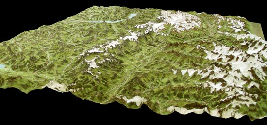
Joachim Eugen Müller from Engelberg never had the chance to visit school, but as an autodidact, he learned to read, write and calculate. He worked as carpenter and often escorted tourists on their trips to the mountains around Engelberg. By order of the fabricant Johann Rudolf Meyer (1739–1813) from Aarau, he created a terrain model of a major part of the Swiss Alps, which was finished in 1797. The scale of this large model was 1:60,000 and it provided a basis for the creation of the "Atlas Suisse par Meyer et Weiss". He worked with the Alsatian geometrician Jean Henri Weiss (1758–1826), who drew the best part of the 16 sheets of the "Atlas Suisse par Meyer et Weiss" in a scale of about 1:108,000 after this model. This Atlas, edited between 1796 and 1802, remained the best map of Switzerland during more than 50 years, until the creation of the Dufour map.
It was a stupendous effort; within no more than eight years (1789–1797) [2] Müller treated an area of 20,000 km2 on his own, equipped with an extremely simple collimation instrument and his feet as principal means of transportation. In summertime, he worked in the field – in wintertime, he created the plaster model in Aarau. Later on, Müller created several other terrain models of different parts of Switzerland. The great model of 1797, sold to Paris 1803, was destroyed in 1903.