Charles François Exchaquet (1746–1792)[1]
Muséum d'histoire naturelle de la Ville de Genève
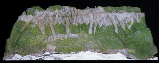
Charles François Exchaquet, son of a Swiss pastor, lived 1780–1792 in Servoz near the Mont Blanc massif (Haute-Savoie, France), where he was ”Directeur général des Mines et Fonderies du Haut Faucigny”. As a result of his explorations around the Mont Blanc, he created a terrain model of the highest mountain in Europe. At this time, the first recorded ascent of Mont Blanc was in 1786, and the first scientists, like Horace-Bénédict de Saussure from Geneva (1740–1799), began to study this region. For the construction of the terrain model, Exchaquet only had his own observations and some compass bearings beside some rudimentary maps available.
Later on, Exchaquet created several models of different Swiss regions such as the model of the Gouvernement d'Aigle on a scale of 1:16,000. Exchaquet created this model by order between 1786 and 1789. Another coloured model made of wood shows the region of Saint Gotthard.
[1] Imhof, Eduard. Bildhauer der Berge. 1981. S.121,122. and Gygax, Fritz. Das topographische Relief in der Schweiz. 1937. S.19-25.
Dictionnaire historique de la Suisse. Exchaquet, Charles-François. 2006. URL: http://www.hls-dhs-dss.ch/textes/f/F29363.php.